|
Site Map
Click on the
following web pages for more offerings:
HOME
About Us
Colorado
Artifactual
Albertype
Publications
Aspen,
Colorado
Business
Directories
Colorado
Colorado
Bottles, historical
Colorado
Business Directories
Colorado Maps
Colorado
Mining Stock Certificates
Colorado
Whiskey Jugs, historical
Cripple Creek,
Colorado
Cripple
Creek Mining Directories
Cripple
Creek mining stock certificates
Denver and
Rio Grande Railroad
Einstein,
Albert
Feynman,
Richard P.
Fitzgerald, F.
Scott
Gunnison
County, Colorado, including Crested Butte
Hecht, Ben
Hemingway,
Ernest
Hutchinson
Soda Bottles
Leadville,
Colorado
Leadville
Directories
San Juan
Mountains, Colorado
Silverton
Railroad
|
|
Yes, we Accept:
PAYPAL,
Venmo & SQUARE |
We
are always interested in purchasing, whether you have a single item or an entire
collection for sale.
© 2022 Mt. Gothic Tomes
| |
|
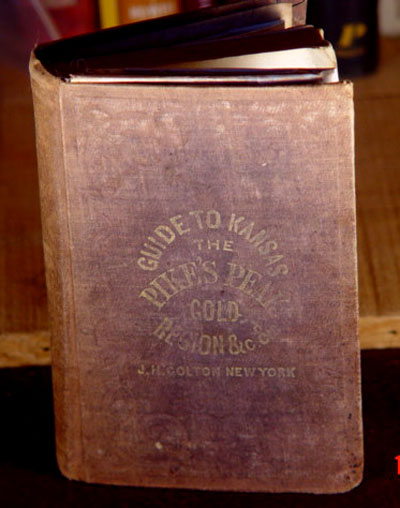
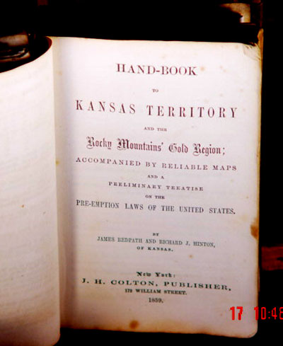
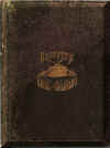
HAND-BOOK TO KANSAS TERRITORY AND THE ROCKY
MOUNTAINS' GOLD REGION ,
1859 |
|
Accompanied by Reliable Maps, By James Redpath and Richard J. Hinton.
New York: J.H. Colton, Publisher, 1859. Original cloth binding, complete with all
maps . |
|
And a Preliminary Treatise on the Pre-Emption Laws of the
United States. |
|
177 pages, plus 1 page of advertisements in front and 5
pages of advertisements in back.
|
|
Dimensions of book: 3-3/4 by 5-13/16 inches |
|
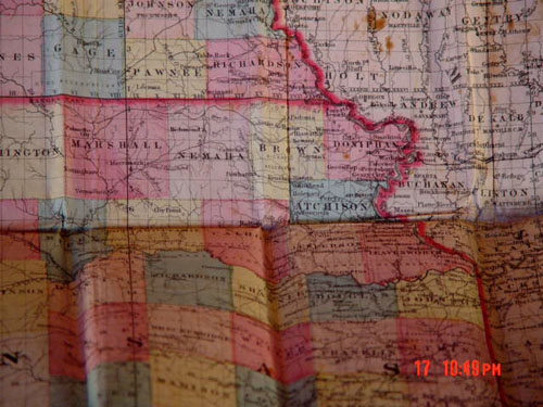
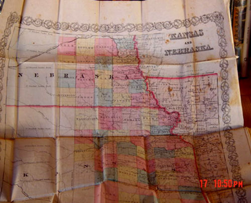
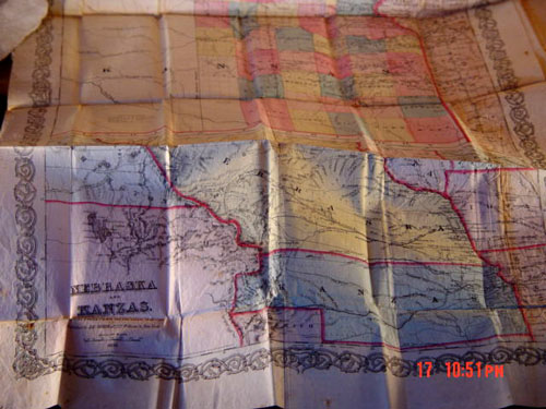
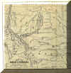
Three maps: two on the same sheet; one on a single
sheet. One sheet with two maps: 16-3/8 by 27 inches; color; upper section
-- "Kansas and Nebraska, published by J.H. Colton & Co., New York;
lower section -- "Nebraska and Kanzas, showing Pike's Peak and the Gold
Region." |
|
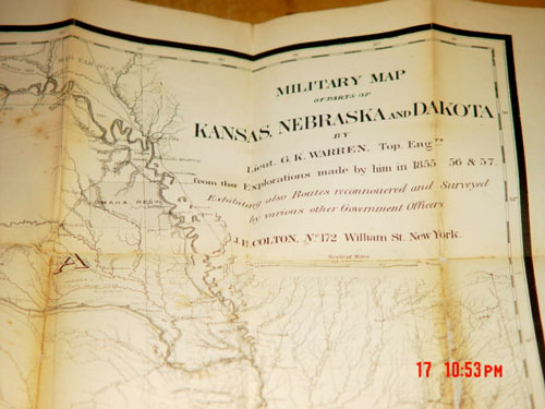
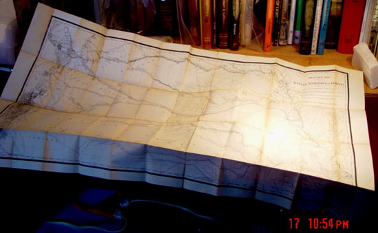
Third map: "Military Map of parts of Kansas, Nebraska and
Dakota by Lieut. G.K.Warren, Top. Engrs. from Explorations made by him in 1855,
'56 & '57. Exhibiting Routes reconnoured and surveyed by various other
Government Officers. J.H. Colton, New York. |
|
Overall condition: good plus to very good. Covers show
wear and fading. Pages have some light foxing. Maps are clean and
bright; however, some hinges show light browning and have been professionally
reinforced on back. Specially made protective box.
Price:
$15,250.00
|
|
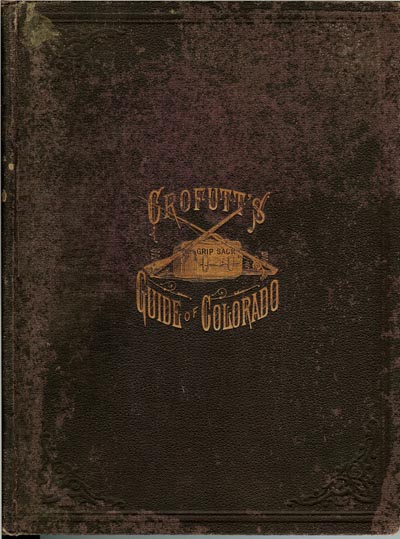
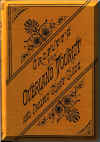
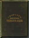
CROFUTT'S GRIP-SACK GUIDE OF COLORADO,
1881 |
|
|
A Complete Encyclopedia of the State: Resources and Condensed Authentic Descriptions of Every City,
Town, Village, Station, Post Office and Important Mining Camp in the State;
Soda, Sulphur, Hot and Medicinal Springs; Summer, Health and Pleasure Resorts;
The Mining, Stock Raising and Farming Interests; Where to Hunt, Fish and View the Most Magnificent Scenery in
the World. Altitudes, Distances, Routes and Fares. In fact it tells you What is Worth Seeing, Where to See It,
Where to Go, How to Go, Where to Shop, and What it Costs. Illustrated.
By George A. Crofutt. Volume I, 1881. Omaha, Nebraska: The Overland Publishing Company; Alvord &
Co., Denver. Original brown cloth binding; gold print on front cover.
183 pages, plus advertisements. Illustrated with
engravings. Foldout Nell's Map of Colorado, 1881. Cover is in good to very good condition. Binding is
strong. Pages are clean and bright; generally in very good plus
condition. Map is in very good plus condition.
|
|
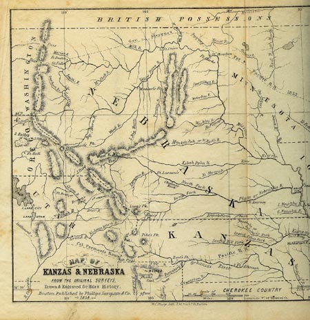
KANZAS AND NEBRASKA,
1854 |
|
The History, Geographical and Physical Characteristics, and
Political Position of those Territories; An Account of the Emigrant Aid Companies
and Directions to Emigrants. By Edward E. Hale. With an Original Map from the Latest Authorities.
Boston: Phillips, Sampson and Company. New York: J.C. Derby. 1854, 1st edition.
Original embossed blue-cloth binding; gold print on spine; 256
pages, plus advertisements. Very good plus condition.
|
|
|
CROFUTT'S NEW OVERLAND
TOURIST AND PACIFIC COAST GUIDE, 1880 |
|
|
Containing a Condensed and Authentic Description of Over One Thousand Three Hundred Cities, Towns, Villages, Stations,
Government Fort and Camps, Mountains, Lakes, Rivers, Sulphur, Soda and Hot
Springs, Scenery, Watering Places, and Summer Resorts; Where To Look for and hunt the Buffalo, Antelope, Denver and other
game; Trout Fishing, etc. etc. In fact, to tell you what is worth seeing
-- where to see it -- where to go -- how to go -- and whom to stop with while
passing over the Union, Kansas, Central and Southern Pacific Railroads, Their Branches and Connections, by Rail, Water and Stage,
From Sunrise to Sunset, and Part of the Way Back; Through Nebraska, Wyoming, Colorado, Utah, Montana, Idaho,
Nevada, California and Arizona. By Geo. A. Crofutt, 1880. Omaha, Nebraska: The Overland Publishing Company; Herald
Print, Omaha, Nebraska. Original tan cloth binding with black print on front cover and
spine; embossing on cloth covers; 18 folding plates; 282 pages. Numerous engravings and maps.
Near fine condition.
Price:
$275.00
|
|
CROFUTT'S NEW OVERLAND
TOURIST AND PACIFIC COAST GUIDE, 1878 - 1879 |
|
Containing a Condensed and Authentic Description of Over One Thousand Three Hundred Cities, Towns, Villages, Stations,
Government Fort and Camps, Mountains, Lakes, Rivers, Sulphur, Soda and Hot
Springs, Scenery, Watering Places, and Summer Resorts; Where To Look for and hunt the Buffalo, Antelope, Denver and other
game; Trout Fishing, etc. etc. In fact, to tell you what is worth seeing
-- where to see it -- where to go -- how to go -- and whom to stop with while
passing over the Union, Kansas, Central and Southern Pacific Railroads, Their Branches and Connections, by Rail, Water and Stage,
From Sunrise to Sunset, and Part of the Way Back; Through Nebraska, Wyoming, Colorado, Utah, Montana, Idaho,
Nevada, California and Arizona. By Geo. A. Crofutt. Volume 1 - 1878 - 9.
Omaha, Nebraska: The Overland Publishing Company. Blakely & Brown, Printers, Chicago; Donohue &
Henneberry, Binders. Original flexible brown cloth binding; gold print on front
cover; 18 folding plates; 322 pages, plus advertisements. Numerous engravings and maps.
Very good condition.
Price:
$275.00
|
|
|
CROFUTT'S NEW OVERLAND
TOURIST AND PACIFIC COAST GUIDE, 1878 - 1879 |
|

|
Containing a Condensed and Authentic Description of Over One Thousand Three Hundred Cities, Towns, Villages, Stations,
Government Fort and Camps, Mountains, Lakes, Rivers, Sulphur, Soda and Hot
Springs, Scenery, Watering Places, and Summer Resorts; Where To Look for and
Price: $275.00
|
|
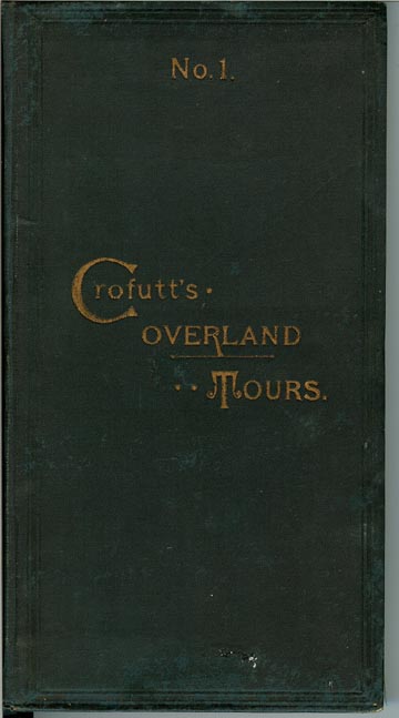
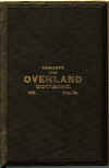
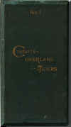
CROFUTT'S OVERLAND TOURS,
1889 |
|
Consisting of Over Six Thousand Miles of Main Tours, and Three Thousand Miles of Side Tours.
Also Six Thousand Miles by Stage and Water. Descriptive - Illustrated. By Geo. A. Crofutt.
Chicago - Philadelphia: H.J. Smith & Co., Publishers, 1889. Sold Wholesale and Retail by
Barkalow Bros., Railway News Agents, Omaha, Nebraska; Union
Depots in Denver, Cheyenne, Ogden and Portland; comprising the Union Pacific,
Oregon Railway & Navigation, and the Denver & Rio Grande systems. Original green cloth binding; gold print on front cover; 264
pages; engravings throughout publication. Large foldout colored map.
Very good plus condition.
Price:
$250.00
|
|
|
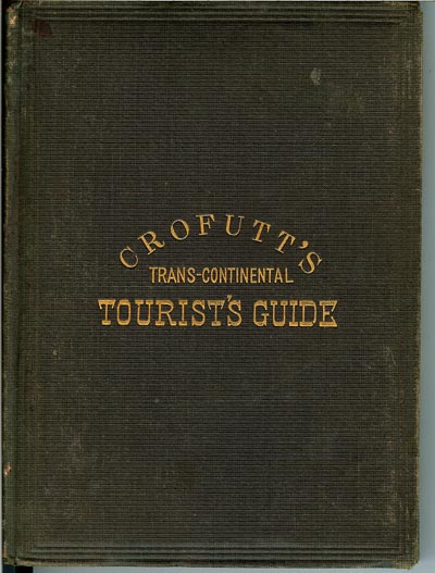
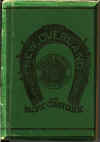
CROFUTT'S TRANS-CONTINENTAL
TOURIST'S GUIDE, 1872 |
|
|
Containing a Condensed and Authentic Description of Over Five Hundred Cities, Towns, Villages, Stations,
Government Fort and Camps, Mountains, Lakes, Rivers, Sulphur, Soda and Hot
Springs, Scenery, Watering Places, and Summer Resorts; Where To Look for and hunt the Buffalo, Antelope, Denver and other
game; Trout Fishing, etc. etc. In fact, to tell you what is worth seeing
-- where to see it -- where to go -- how to go -- and whom to stop with while
passing over the Union Pacific Railroad, Central Pacific Railroad of Cal., Their Branches and Connections, by Rail, Water and Stage,
From the Atlantic to the Pacific Ocean. Illustrated. Fourth Volume, Third Annual Revise.
By Geo. A. Crofutt, Publisher, New York. 1872. Original black cloth binding; gold print on front cover; 1 folding
plate; 224 pages, plus advertisements. Numerous engravings and plate maps.
5 large foldout maps. Very good plus condition.
SOLD
|
|
THE PACIFIC TOURIST.
J.R. BOWMAN'S ILLUSTRATED TRANS-CONTINENTAL
GUIDE OF TRAVEL
|
|
FROM THE ATLANTIC TO THE
PACIFIC OCEAN
Containing Full Descriptions of Railroad Routes Across the Continent, All Pleasure Resorts and
Places of Most Noted Scenery in the Far West, Also of All Cities, Towns,
Villages, U.S. Forts, Springs, Lakes, Mountains Routes of Summer Travel, Best Localities for Hunting, Fishing,
Sporting and Enjoyment, with all Needful Information for the Pleasure Traveler,
Miner, Settler and Business Man. A Complete Traveler's Guide of The Union and Central Pacific
Railroads, and all points of business or pleasure travel to California, Colorado, Nebraska, Wyoming, Utah, Nevada,
Montana, The Mines and Mining of the Territories, The Lands of the Pacific
Coast, The Wonders of the Rocky Mountains, the Scenery of the Sierra Nevadas,
The Colorado Mountains, The Big Trees, The Geysers, The Yosemite, and the
Yellowstone.
Frederick E. Shearer, Editor
With special contributions by Prof. F.V. Hayden, Clarence
King, Capt. Dutton, A.C. Peale, Joaquin Miller and J.B. Davis. Illustrations by Thomas Moran, A.C. Warren, W. Snyder, F.
Schell, H.W. Troy, A Will. Engravings by Meeder & Chubb. J.R. Bowman, Publisher: New
York, 1882 - 83. Original maroon embossed cloth binding; 372 pages, plus index
and advertisements. Numerous engravings. Very good condition.
Price: $200.00
|
|
CROFUTT'S NEW OVERLAND
TOURIST AND PACIFIC COAST GUIDE, 1883 |
|
Containing a Condensed and Authentic Description of Over One Thousand Three Hundred Cities, Towns, Villages, Stations,
Government Fort and Camps, Mountains, Lakes, Rivers, Sulphur, Soda and Hot
Springs, Scenery, Watering Places, and Summer Resorts; Where To Look for and hunt the Buffalo, Antelope, Denver and other
game; Trout Fishing, etc. etc. In fact, to tell you what is worth seeing
-- where to see it -- where to go -- how to go -- and whom to stop with while
passing over the Union, Kansas, Central and Southern Pacific Railroads, Their Branches and Connections, by Rail, Water and Stage,
From Sunrise to Sunset, and Part of the Way Back; Through Nebraska, Wyoming, Colorado, Utah, Montana, Idaho,
Nevada, California, Arizona and New Mexico. By Geo. A. Crofutt, 1883.
Omaha, Nebraska and Denver, Col.: The Overland Publishing
Company. Original flexible green cloth binding; black print on front
cover; 18 folding plates; 275 pages, plus advertisements. Numerous engravings and maps.
Very good condition.
Price: $200.00
|
|
|
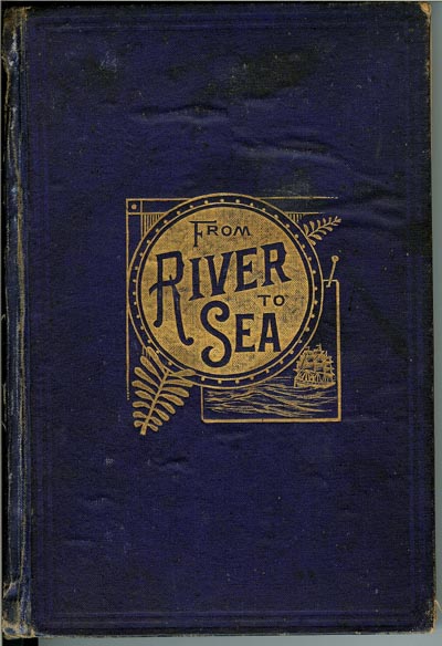
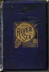
FROM RIVER TO SEA;
A Tourists' and Miners'
Guide, 1882
|
|
|
From the Missouri River to the Pacific Ocean via Kansas, Colorado, New Mexico, Arizona and California.
Chas S. Gleed, Editor. Chicago: Rand,McNally & Co., 1882.
Original blue cloth covers with gold print on front cover; 240
pages, plus 16 pages of advertisements in back of book; numerous engravings
throughout. Condition: good plus to very good; some spine repair; interior
pages bright and clean
Price: $150.00
|
|