|
Site Map
Click on the
following web pages for more offerings:
HOME
About Us
Colorado
Artifactual
Albertype
Publications
Aspen,
Colorado
Business
Directories
Colorado
Colorado
Bottles, historical
Colorado
Business Directories
Colorado Maps
Colorado
Mining Stock Certificates
Colorado
Whiskey Jugs, historical
Cripple Creek,
Colorado
Cripple
Creek Mining Directories
Cripple
Creek mining stock certificates
Denver and
Rio Grande Railroad
Einstein,
Albert
Feynman,
Richard P.
Fitzgerald, F.
Scott
Gunnison
County, Colorado, including Crested Butte
Hecht, Ben
Hemingway,
Ernest
Hutchinson
Soda Bottles
Jackson,
William Henry
Leadville,
Colorado
Leadville
Directories
San Juan
Mountains, Colorado
Silverton
Railroad
|
|
Yes, we Accept:
PAYPAL,
Venmo & SQUARE |
We
are always interested in purchasing, whether you have a single item or an entire
collection for sale.
© 2024 Mt. Gothic Tomes
| |
|
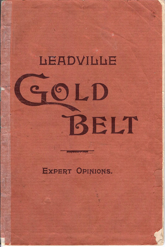
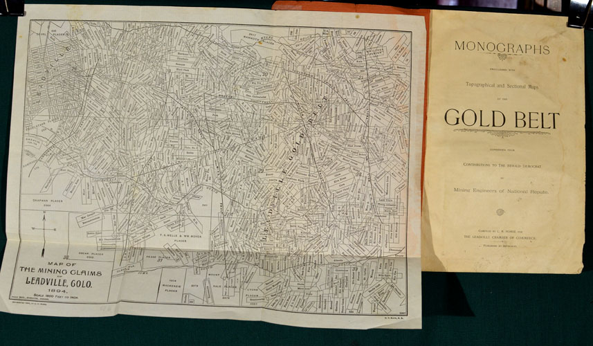
MONOGRAPHS
Embellished with Topographical and Sectional Maps of the GOLD BELT,
Condensed from Contributions to the Herald Democrat by Mining Engineers of
National Repute, Compiled by C. H. Morse for The Leadville Chamber of
Commerce, 1894 |
|
|
|
Original
brown printed brown wrappers; 24 pages. Compiled by C. H. Morse,
Hotel Vendome, Leadville, Colorado, 1894. Two
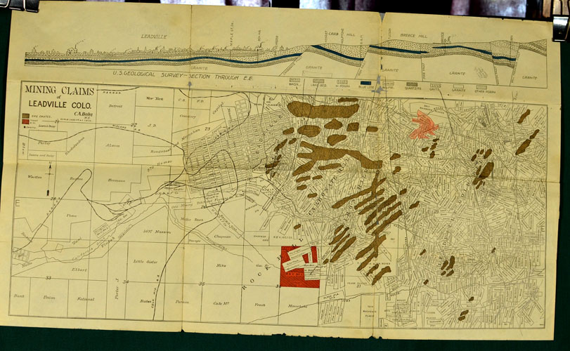
fold-out maps: Map of the Mining Claims of Leadville, 1894, C. H. Morse,
14 inches by 11 inches; Mining Claims of Leadville, Colorado and the Gold
Belt, C. A. Bohn, M. E., 24-1/2 inches by 14 inches.
“The Ophir of Colorado,” Beginning of the Third or Golden Era
of Leadville’s Wonderful Mining History, by A. A. Blow, M.E.
“Exploitation of a Theory, Practical Demonstration of the Views
of Mining Men of National Renown,” by John F. Campion, Manager of the
Ibex, Stag, Wapiti, Yak, and others mines.
“Its History and Geology, Not a New Discovery but a Part and
Parcel of the Famous Silver Area,” by Max Boehmer, M.E.
“How It All Came About: Gold in the Mountain-Tops, to the East of
Us and to the West of Us,” by Tingley S. Wood.
“Where the Gold Is Found: How the Auriferous Ore Zone Has Been
Widened by Intelligent Propsecting,” by Louis S. Noble, M.E.
“An Immense Mother Vein: New and Valuable Suggestions regarding
the Geology and Mineralogy of the Belt,” by A. V. Bohn, M.E.
“Trends to the North: Views of a Practical Mining Man Regarding
the Extent and Characteristics of the Belt,” by R. E. Taft, M.E.
“The First Gold Era: Existence of the Precious Metal in the
Leadville District known for Forty Years.”
Condition: good to good plus: chipped wrappers; interior pages
lightly toned and several lightly soiled. |
|
|
|
|
|
Original
hand-drafted
SILVER
CORD COMBINATION MINING COMPANY
Map,
dated 1883, Leadville, Colorado |
|
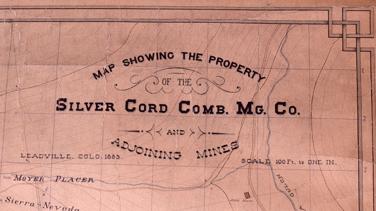
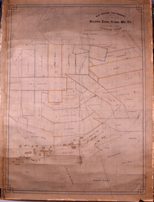
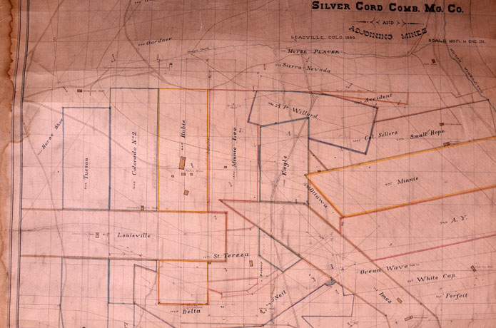
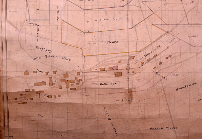
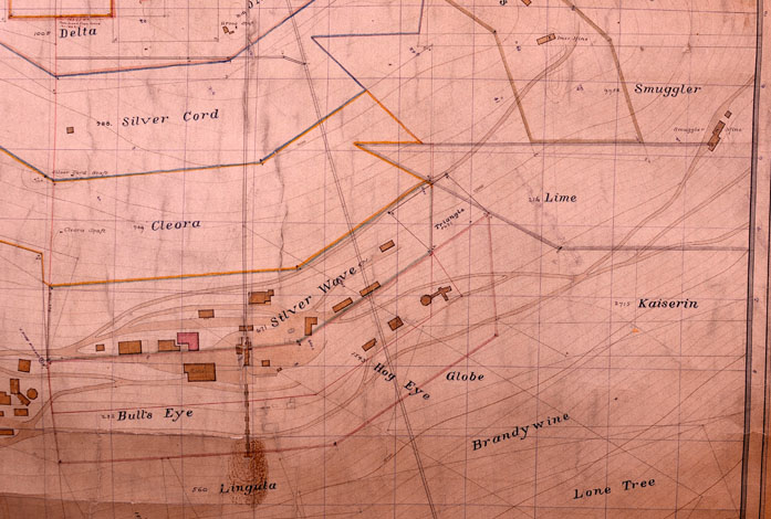
MAP
SHOWING THE PROPERTY OF THE SILVER CORD COMBINATION MINING COMPANY,
and the Adjoining Mines, Leadville, Colorado, 1883. Scale: 100 feet
= 1 inch ATTRIBUTED
TO MINING ENGINEER A.
A. BLOW, LEADVILLE,
COLORADO |
|
Paper
mounted on linen (1883). Dimensions: 34-1/2 inches in width by 46
inches in height. Condition: very good; original pen-drafted map
with some light fraying and water damage to map edges; minimum amount of
fading; bright colors along lines of mining claims as well as those
composing topographical features. |
PRICE:
$3,500.00
|
THE
SILVER CORD COMBINATION MINING COMPANY, 1883. J. B. Grant was
president of the Company; Tingley S. Wood, general manager. The
Company owned the Silver Wave and seven other locations, besides 60 acres
of additional surface ground, situated on Iron Hill and adjoining the Iron
Silver Mining Company's property, about 1 mile from Leadville, Lake
County, Colorado (reference: COLORADO MINING DIRECTORY, 1883, compiled by
Corregan and Lingane). |
|
The
vein was that of a contact, varying in width from 2 to 50 feet. A
business compromise with the Iron Silver Company, along with the purchase
of the Silver Wave, gave the Silver Cord 900 feet along the apex of the
vein. The pay-streak contained lead and iron carbonates, as well as
oxides, in a decomposed porphyry gangue. After milling and sorting,
production was 20 - 25% lead and 20 - 25 ounces of silver per ton.
Development work: inclines, shafts, levels and winzes, amounting to
thousands of feet, showing large ore-reserves and extending into the
underlying lime. |
James
Benton Grant, who was one of the principal owners of the Silver Cord
Combination Company, was the third governor of Colorado. In 1878,
Grant conceived and developed the Grant Smelter, located just west of the
Harrison mill. Shortly after the Grant mill opened another opened
for business: the Omaha Smelting and Refining Company. Soon, other
smelter and reduction operations went into business. By 1880, and in
order to remain profitable, the Grant and Omaha mills combined assets. |
|
In
1883, the
Silver Cord - Silver Wave Combination property produced approximately 150
tons of silver ore daily, surpassed only by the Iron Silver Mine, which
produced approximately 280 tons of silver ore daily. In this same
year, the Silver Cord Combination was one of the first mining companies to
introduce electricity
early in its operations. |
|
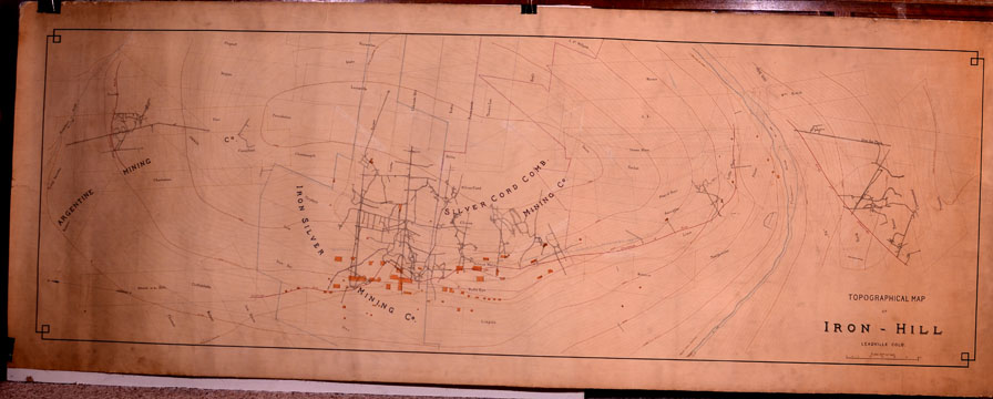
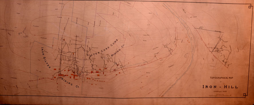
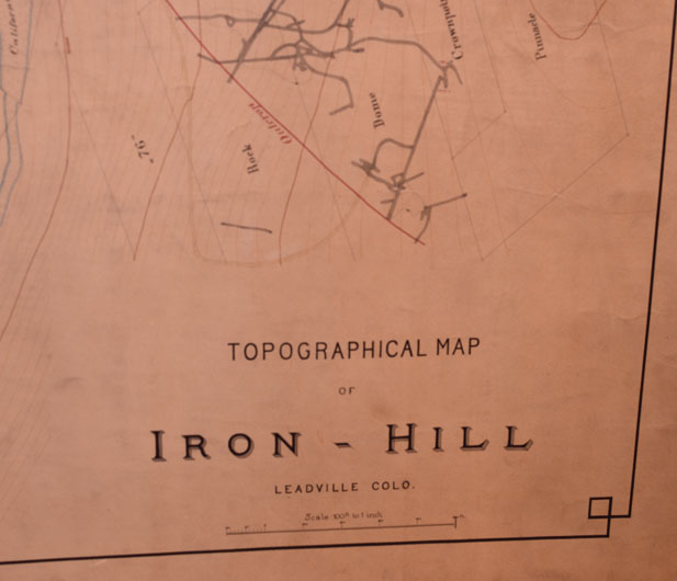
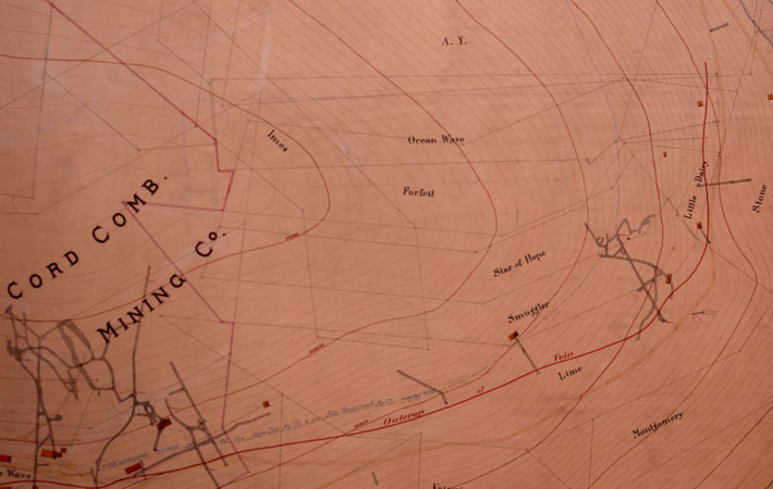
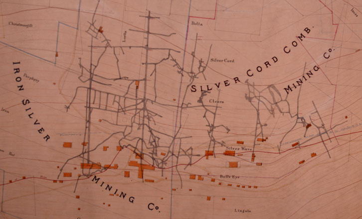
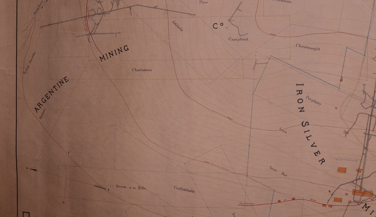
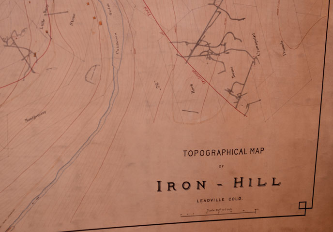
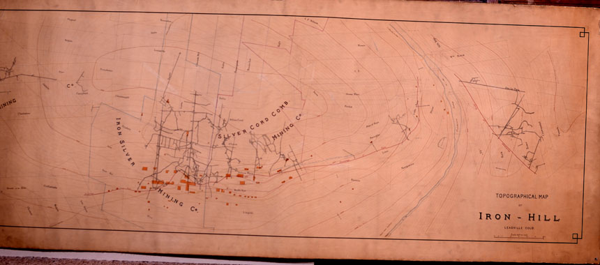
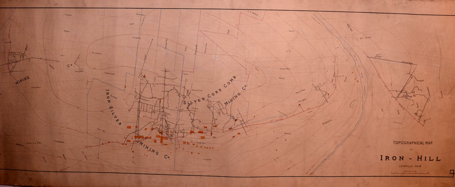
TOPOGRAPHICAL
MAP OF IRON HILL, LEADVILLE, COLORADO, 1883 |
|
Complementary
map to
MAP
SHOWING THE PROPERTY OF THE SILVER
CORD COMBINATION MINING COMPANY
Map,
dated 1883, Leadville, Colorado |
|
Hand-drafted
on original paper contemporaneously mounted on linen, 1883.
Dimensions: 82 inches in width by 31 inches in height. Condition:
very good plus to near fine. Possibly by the same draftsman as the
one who penned the Map of the Property of the Silver Cord Combination
Mining Company, as neither map is signed, however, both concern the Silver
Cord Combination Mining Company. |
|
Detail
images of Topographical Map of Iron Hill, Leadville, Colorado, 1883 |
|