|
Site Map
Click on the
following web pages for more offerings:
HOME
About Us
Colorado
Artifactual
Albertype
Publications
Aspen,
Colorado
Business
Directories
Colorado
Colorado
Bottles, historical
Colorado
Business Directories
Colorado Maps
Colorado
Mining Stock Certificates
Colorado
Whiskey Jugs, historical
Cripple Creek,
Colorado
Cripple
Creek Mining Directories
Cripple
Creek mining stock certificates
Denver and
Rio Grande Railroad
Einstein,
Albert
Feynman,
Richard P.
Fitzgerald, F.
Scott
Gunnison
County, Colorado, including Crested Butte
Hecht, Ben
Hemingway,
Ernest
Hutchinson
Soda Bottles
Jackson,
William Henry
Leadville,
Colorado
Leadville
Directories
San Juan
Mountains, Colorado
Silverton
Railroad
|
|
Yes, we Accept:
PAYPAL,
Venmo & SQUARE |
We
are always interested in purchasing, whether you have a single item or an entire
collection for sale.
© 2024 Mt. Gothic Tomes
| |
|
Railroad books, pamphlets, stock certificates, timetables, and
more on Colorado and Western railroads.
RAILROAD BOOKS A
|
|
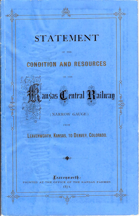
STATEMENT
OF THE CONDITION AND RESOURCES OF THE KANSAS CENTRAL RAILWAY (Narrow
Gauge) from LEAVENWORTH, KANSAS to DENVER, COLORADO, 1871 |
|
Publication
in original black- and gold-printed blue wrappers; 19 pages, plus fold-out
map. Near fine condition. Early Colorado Territory
railroad. Leavenworth: Printed at the Office of the Kansas Farmer,
1871. L. T. Smith, President. Report of United States
Surveyors. Professor Mudge's Report, concerning agriculture and
geology along the route of the Kansas Central. Kansas fruits.
Yield of farm products per acre for the year 1869. Kansas Central
route, revenue, means for construction, charter, first mortgage
bond. Fold-out map: 23 inches by 12-1/2 inches; Map of the Kansas
Central Railway and Its Connections; Leavenworth to Denver, Ft. Dodge, and
Cheyenne.
SOLD |
|
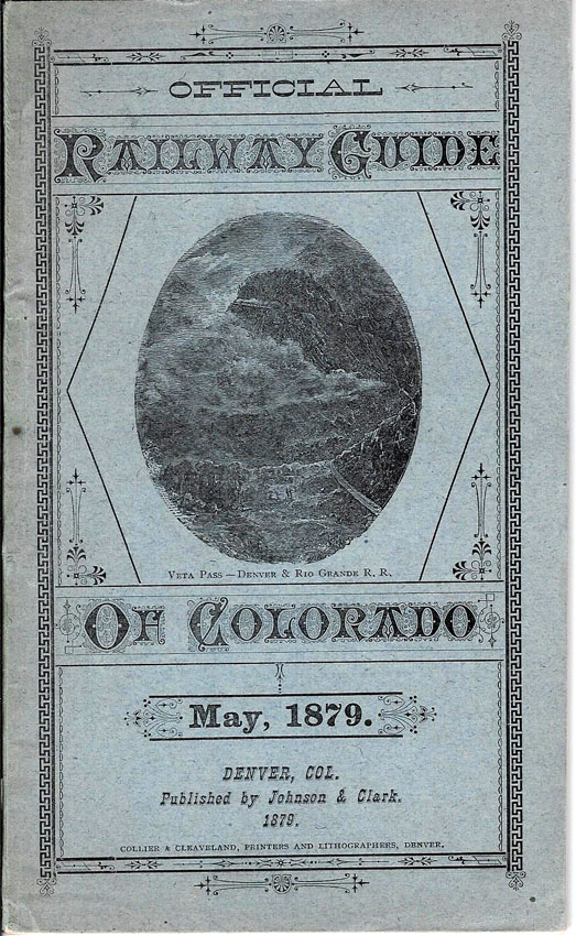
OFFICIAL
RAILWAY GUIDE OF COLORADO, May 1879 |
|
Original
illustrated wrappers. Denver, Col. Published by Johnson &
Clark, 1879. Near fine condition; 46 pages. Collier &
Cleaveland, Printers and Lithographers, Denver. Publication contains
information on the following: Stage Lines; Atchison, Topeka & Santa Fe
Time Table; Black Hawk; Boulder; Boulder Valley Time Table; Colorado
Central Time Table; Central City; Colorado Springs; Canon City; Denver;
Denver Pacific Railroad Time Table; Distances from Denver; Denver &
Rio Grande Railroad Time Table; Denver & South Park Time Table; Estes
Park; Editorial; Express Companies; Fire Alarm Boxes; Golden; Georgetown;
Hotel Directory; Information for Tourists and Hunters; Idaho Springs;
Kansas Pacific Railroad Time Table; Manitou Springs; Post Office Bulletin;
Pueblo; Street Car Time Table; Silver Cliff; Through Rates of Fares from
Denver; Union Pacific Railroad Time Table; and, Veta Pass. Near fine
condition. Advertisements.
SOLD |
|
ABOUT
THE LINE OF THE GILPIN AND CLEAR CREEK DISTRICT RAILWAYS, December 1904 |
|
|
|
Original
copper-printed tan wrappers; 29 pages, plus fold-out map of The Gilpin and
Clear Creek District Railway. Published by The Hall Construction
Company, Denver, Colorado. Contents includes the following: Letter -
D.H. Moffat, President of D.N.W.&P. Ry.; Something About Gilpin
County; Recent Mineral Production; Southern Gilpin County; Northern Gilpin
County; Gilpin County Miners; Veins, Continuity Laterally; Present Mining
Situation in Gilpin County; Metallurgy of Gilpin County; More Mills
Needed; Existing Railroad Facilities; The Gilpin & Clear Creek
District Ry. and Branches; New Mills on the Gilpin & Clear Creek
District Ry.; What the G.&C.C.D. Ry. Will Do for Gilpin County; Our
Engineer; Engineer's Report; Grades and Curvature; Endorsement of
Prominent People; and more. Very good plus condition. Detailed
map, dimensions: 18 inches by 12 inches; Clason Map Company, Denver.
Also included: Prospectus of the Gilpin and Clear Creek District Railway
Company, Bond Issue, dated January 1, 1906; 4-page fold-over.
SOLD |
|
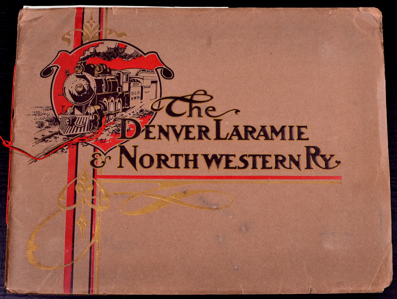
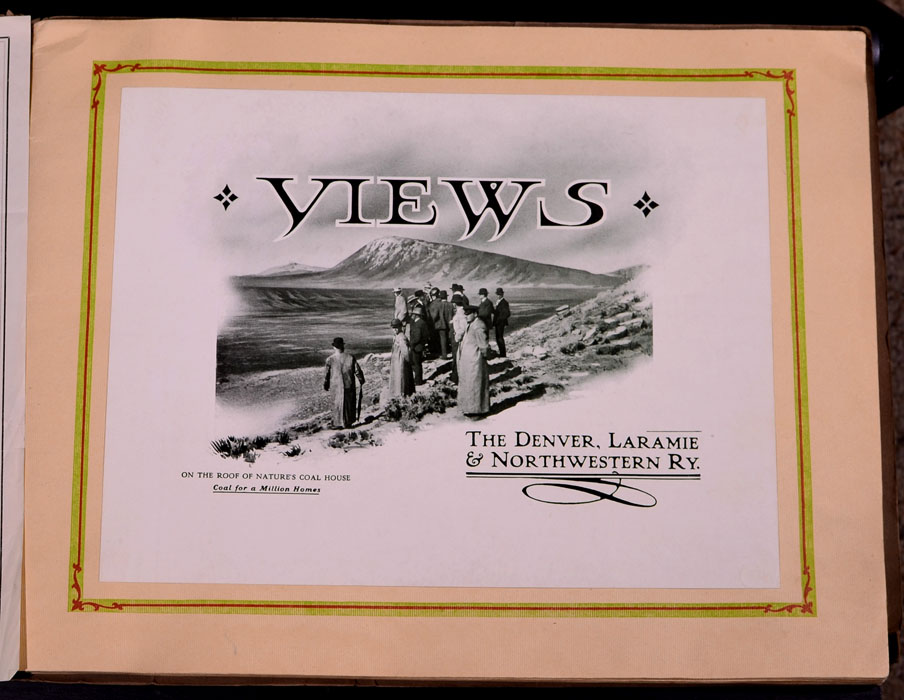
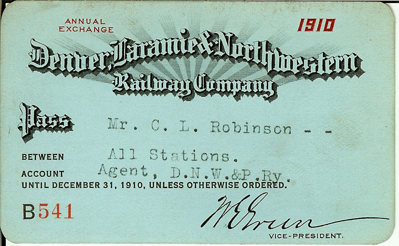
VIEWS:
THE DENVER, LARAMIE & NORTHWESTERN RAILWAY, circa 1910 |
|
No
publisher; no date. Subtitled, "On the Roof of Nature's Coal
House, Coal for a Million Homes." Original illustrated tan
wrappers; tie-bound; 32 pages, plus fold-out map. Dimensions: 14-1/4
inches in width and 11 inches in height. Printed by The Smith-Brooks
Co., Engravers, Printers, Denver, Colo. Fold-out map: Showing some
of the industries and resources of the territory reached by the Denver,
Laramie & Northwestern Railway (dimensions: 20 inches by 14 inches) |
|
|
|
|
|
Views
include: Moffat Road Station, Denver; Moffat Road freight depot; Engine
No. 101; Smelter and factory district of Denver; Argo Smelter; Moffat
line; agricultural scenes; Lamb-feeding pens in the Poudre Valley; Through
market gardening district of South Platte Valley; Potatoe-hauling team in
Milliken District; Clear Creek Bridge; Fish Creek Canon; Colorado alfalfa
fields; Tract for Town of Cline, Northwestern Land & Iron Company;
Irrigation canals; Irrigation canal of Lupton section; Wildcat hills;
Irrigation canals in Platteville District; Denver, Laramie &
Northwestern Railway at confluence of Big and Little Thompson rivers;
Grading streets in Milliken; Beat-loading near Milliken; Bridges across
Platte River; Residences of Platte River Valley; Street scene in Greeley,
Colorado; Greeley sugar factory; New Town of Severance; New Town of
Wellington, Laramie County; Laramie Valley; 100,000 herd of sheep, Laramie
Plains; Street scene in Laramie, Wyoming; Aldrich's Gorge; Development in
Elk Mountain coal fields; Mines in Elk Mountain District; Executive
offices of the Denver, Laramie & Northwestern Railway; Map of the
Terminals, Trackage and Depot Grounds of the Denver, Laramie &
Northwestern Railway & Moffat Road in Denver.
Near
fine condition.
|
|
SOLD
|
|
OFFICIAL LOCAL TIME
TABLES:
DENVER
&
RIO GRANDE
RAILROAD, Scenic Line of the World, through
Colorado,
Utah
and
New Mexico, July 1888. |
|
Original illustrated tan wrappers; 128 pages. Engravings of local scenes; local business and hotel
advertising; description of towns along the railroad route; index to stations;
shipping guide; and numerous timetables.
Condition: good plus; wrappers and some pages are fragile.
PRICE:
$500.00
|
|
DENVER
AND RIO GRANDE WESTERN - WESTERN PACIFIC - "The Scenic Life
of the World," The Great Salt Lake Route. Train schedules for the
Denver & Rio Grande Western Railway Company, dated June - July 1925.
Printed by Poole Bros., Chicago. Fold-over pamphlet, in its original
illustrated covers; 54 pages. Train schedules. Map of the Denver
& Rio Grande Western Railroad, Western Pacific Railroad and connections
spread across pages 27 - 30. Advertisements for businesses along
routes. Condition: very good; some light age signs; several professionally
repaired short, closed-end tears. Pages bright and clean.
Price: |
|
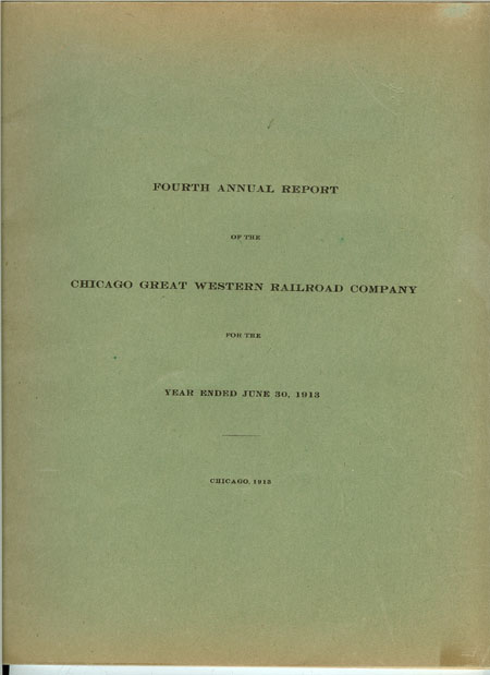
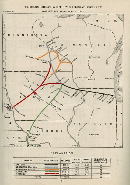
FOURTH ANNUAL REPORT
OF THE CHICAGO GREAT WESTERN RAILROAD
COMPANY
for the Year ended June 30, 1913
|
|
Chicago, Illinois, 1913. Original printed green wrappers; 45 pages; 2 maps; charts and
descriptive detail. Includes development and improvements of the railroad in
Minnesota, Iowa, Nebraska, Missouri, Kansas, and other states. Financial
statements; operating revenues; transportation expenses; and other
details. Also information on the Wisconsin, Minnesota & Pacific
Railroad, as well as the Mason City & Fort Dodge Railroad. Very good condition: some light fading to covers; pages clean
and bright. |
|
|
|
A
HANDBOOK OF COLORADO, For the Convenience of Prospective Visitors
of the State, Burlington Route, circa 1905, printed by Poole Bros.,
Chicago. Publication is in its original enamel-coated, colored wrappers;
56 pages; with fold-out map tipped onto inside of rear wrap. Numerous
half-tone illustrations. Towns, stations, post offices, etc., listed along
route, with details of places and illustrations. Condition: very good plus
to near fine; publication is bright, clean, and fresh, with only the lightest
bit of wear.
PRICE:
$500.00
_________________________________________________
Northern Pacific Railway
WONDERLAND,
1906, by Olin D. Wheeler. This Number describes: The
Yellowstone National Park; A Trip through the Bitterroot Mountains; Columbia
River and Puget Sound Region; The Queniut Indians of the Northwest Coast; and
gives Some Information About Alaska. A.M. Cleland, General Passenger
Agent, Northern Pacific Railway, St. Paul, Minnesota, 1906. Publication is
in its original illustrated maroon wrappers; square-bound; 75 enamel-coated
pages; map in rear. Numerous half-tone photographic illustrations of
scenes along the route; plus, descriptive. Written by Olin D. Wheeler, who
was also the author of the acclaimed, TRAIL OF LEWIS AND CLARK,
published by Putnam. Condition: very good plus to near fine.
Two-page map at read showing the Northern Pacific, Yellowstone Park Line, and
Connections.
PRICE:
$300.00
REPORT TO THE STOCKHOLDERS OF THE UNION PACIFIC RAILWAY
COMPANY, for the Year 1883; New York: Rufus Adams & Co.,
Stationers and Printers. Ex-library; original front wrap present; new
endpapers and fly-leafs; 36 pages; plus, in same publication, REPORT OF THE
GOVERNMENT DIRECTORS OF THE UNION PACIFIC RAILWAY COMPANY MADE TO THE SECRETARY
OF THE INTERIOR, 1883; New York: Rufus Adams & Co.; 27 pages.
Condition of publication: very good plus. Original foldout map in front of
publication; very good plus to near fine condition. Ex-library binding has
actually helped preserve this publication, rather than detract from it.
One library stamp on title page, along with several short sections of
tape.
PRICE:
$950.00
____________________________________________
(Gen Dodge's Paper on the Transcontinental Railways) PAPER READ BEFORE
THE SOCIETY OF THE ARMY OF THE TENNESSEE AT ITS TWENTY-FIRST ANNUAL REUNION AT
TOLEDO, OHIO, September 15, 1888, by Major-General Grenville M. Dodge,
reprinted with comments thereon by General William T. Sherman, President of the
Society. New York: Unz & Co., Printers, 1899. Publication in its
original green-printed wrappers; square-bound; 50 pages; several half-tone
photographs. Condition: very good; wraps have some tiny chips and show
aging.
PRICE:
$300.00
_____________________________________________________
Hollenback, Frank R. THE
LARAMIE
PLAINS LINE:
Laramie,
Wyoming
to
Coalmont
,
Colorado.
Denver
,
Colorado
: Sage Books, 1960, Number 64 of 300 copies, signed by author, hardback,
dust-jacketed, first limited edition. Book
is in its original tan cloth binding with map printed on front cover; brown
print on spine; 94 pages; illustrated; fold-out map tipped onto back fly-leaf.
Book is in very fine condition; dust jacket is in fine condition, with
only the faintest touch of color-lightening.
PRICE:
$300.00
______________________________________________________
|
|