|
Site Map
Click on the
following web pages for more offerings:
HOME
About Us
Colorado
Artifactual
Albertype
Publications
Aspen,
Colorado
Business
Directories
Colorado
Colorado
Bottles, historical
Colorado
Business Directories
Colorado Maps
Colorado
Mining Stock Certificates
Colorado
Whiskey Jugs, historical
Cripple Creek,
Colorado
Cripple
Creek Mining Directories
Cripple
Creek mining stock certificates
Denver and
Rio Grande Railroad
Einstein,
Albert
Feynman,
Richard P.
Fitzgerald, F.
Scott
Gunnison
County, Colorado, including Crested Butte
Hecht, Ben
Hemingway,
Ernest
Hutchinson
Soda Bottles
Jackson,
William Henry
Leadville,
Colorado
Leadville
Directories
San Juan
Mountains, Colorado
Silverton
Railroad
|
|
Yes, we Accept:
PAYPAL,
Venmo & SQUARE |
We
are always interested in purchasing, whether you have a single item or an entire
collection for sale.
© 2024 Mt. Gothic Tomes
| |
|
|
|
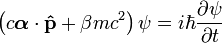
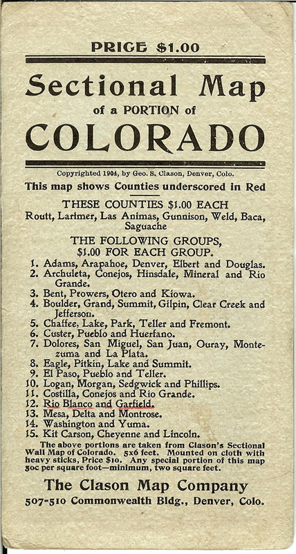
(Clason
Map Company) RIO
BLANCO and GARFIELD COUNTIES: SECTIONAL MAP OF A PORTION OF COLORADO.
Circa 1905. Pocket map.
The Clason Map Company, 507 - 510 Commonmwealth Building, Denver,
Colorado. Highly detailed map
showing county lines; township lines; town, cities, and railroad stations;
rivers, creeks, lakes and other topographical features.
Agricultural and livestock map: White River Plateau Timber Land
Reserve. Printed in tan, red,
green, and black. Map
dimensions: 20-1/2 inches across by 11 inches in height.
Near fine condition.
Price: $250.00
SOLD
|
|
|
|
|
|
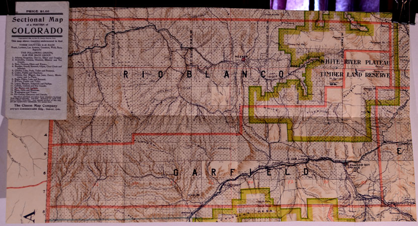
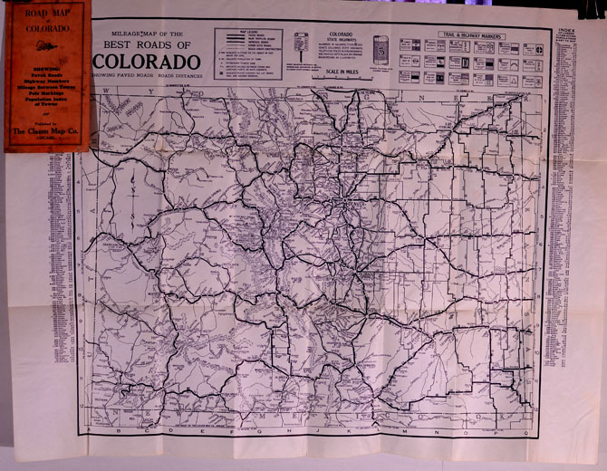
(Clason
Map Company) ROAD
MAP OF COLORADO, showing paved roads, highway numbers, mileage
between towns, pole markings, population index of towns.
Circa 1917. Original
blue printed orange folder. Pocket
map. Title on foldout map: MILEAGE MAP OF THE BEST ROADS OF COLORADO, showing paved
roads and road distances. Index
of cities, towns and populations on right and left sides of map; legend of
trail and highway markets. Map
dimensions: 27-1/4 inches across by 21 inches in height.
Near fine condition. Black
print. Price: $185.00 |
|
|
| |
|
(Clason
Map Company) ROAD
MAP OF COLORADO, ca. 1925. Pocket
map. Clason Map of Colorado
detailing paved roads, main travelled roads, improved roads, other auto
roads, and roads under construction; Colorado state highways; trail &
highway markers; index of larger cities giving populations & key to
map. Dimensions: 27-3/4 inches
across by 21 inches in height. Printed
in blue ink. “Compliments of
United States National Bank, Denver, with which is affiliated The United
States National Company, Investment Securities.”
In original cream-colored illustrated stiff folders.
Near fine condition. |
|
SOLD
|
|
|
|
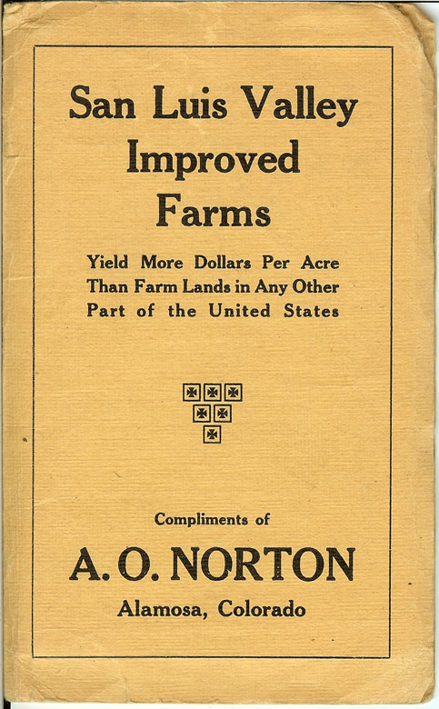
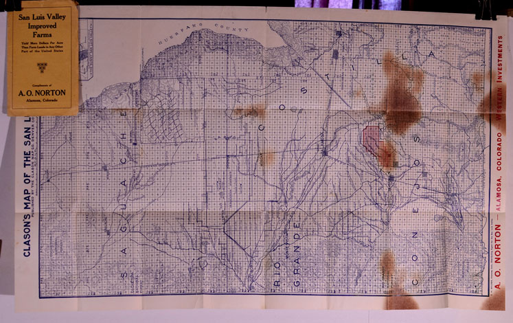
(Clason
Map Company) SAN
LUIS VALLEY IMPROVED FARMS, “Yield more dollars per acre than
farm lands in any other part of the United States, Compliments of A. O.
Norton, Alamosa, Colorado.” CLASON’S
MAP OF THE SAN LUIS VALLEY, published by The Clason Map Company,
Denver, Colorado, 1910. Pocket
Map: The San Luis Valley, Colorado. Saquache,
Costilla, Rio Grande, and Conejos countie, Colorado.
Pocket map: blue print on cream-colored folder.
C. H. Wilder, Alamosa, Colo., Distributing Agent for the San Luis
Valley. CLASON’S MAP OF THE
SAN LUIS VALLEY. Inset map:
“Map of Colorado Showing Location of The ‘Sunny’ San Luis Valley.”
Dimensions: 17 inches across by 27-3/4 inches in height.
Highly detailed showing cities, towns, and villages, railroad and
roads, townships, and topography. A.
O. Norton – Alamosa, Colorado – Western Investments.
Very good condition: several light-colored brown stains on lower
portion of map that are quite evident but do not disrupt information (more
of a beauty perception). In
original stiff pictorial wrappers. Price: $200.00 |
|
|
|
|
|
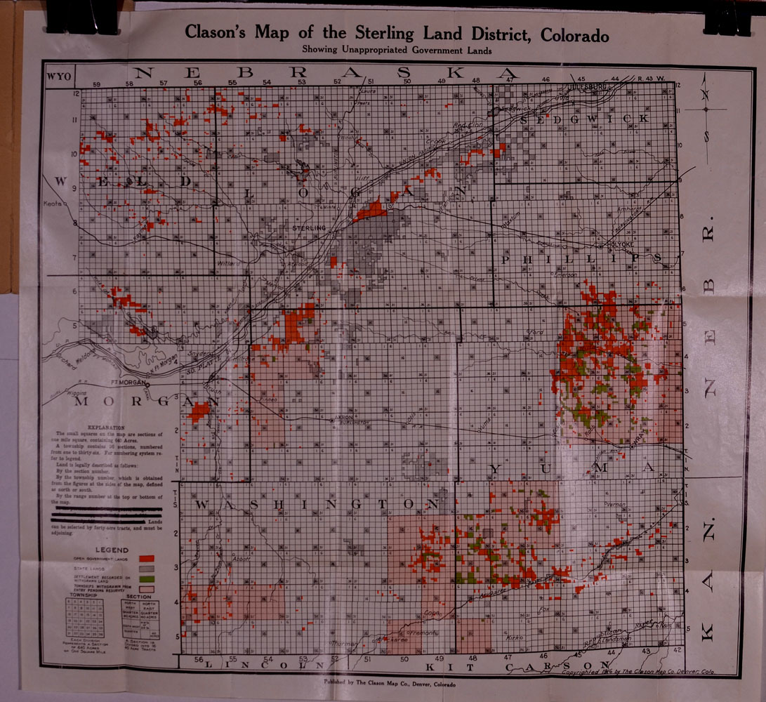
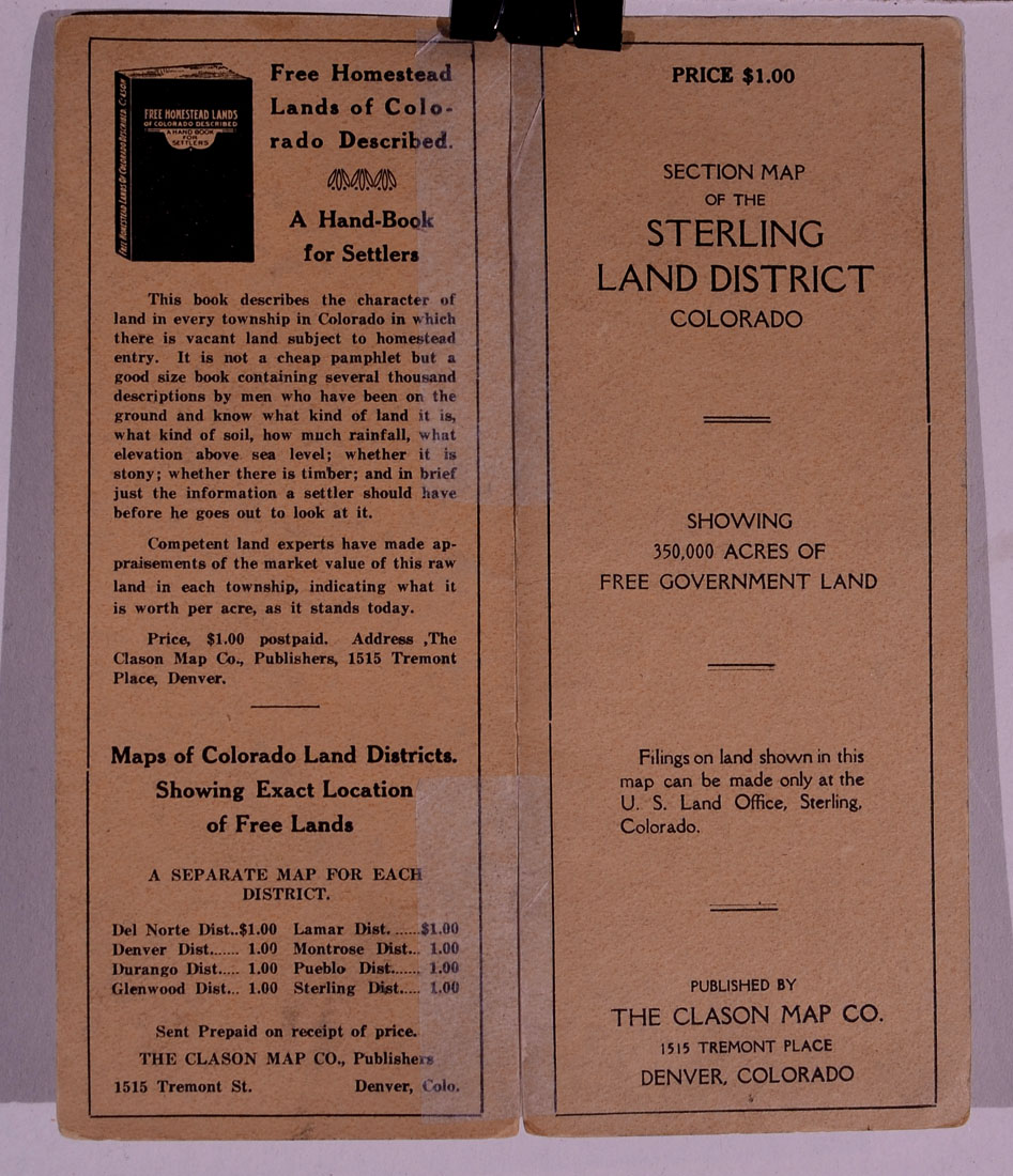
(Clason
Map Company) SECTION
MAP OF THE STERLING LAND DISTRICT, COLORADO, showing 350,000 acres
of Free Government Land. Published
by The Clason Map Company, 1515 Tremont Place, Denver, Colorado, 1916.
Pocket map. Original
printed tan folder. Map title:
Clason’s Map of the Sterling Land District, Colorado, showing
unappropriated Government Lands. Map
dimensions: 20-1/2 inches across by 18 inches in height.
Black, green and orange print.
Exhibits Weld, Logan, Sedgwick, Phillips, Morgan, Washington, and
Yuma counties, Colorado. Near
fine condition,. Price:
$275.00
|
|
|
|
|
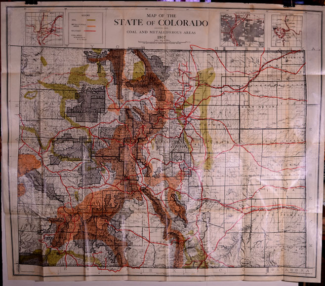
(Coal
and Metalliferous areas, Colorado) MAP
OF THE STATE OF COLORADO SHOWING COAL AND METALLIFEROUS AREAS,
1907. The Smith-Brooks Co.,
Engravers and Printers, Denver. Compiled
by A. F. Dinsmore. Traced and
Lettered by William Bauman, Jr. Top
of map has 3 inset maps of the Leadville Mining District, City of Denver,
and the Cripple Creek Mining District.
Dimensions: 34 inches across by 29-1/2 inches in height.
5-color map. County
lines; railroads and roads; topography; towns and cities.
Highly detailed. Condition:
very good plus; some curatorial reinforcement on back of hinges. |
|
Price:
$300.00
|
|
|
|
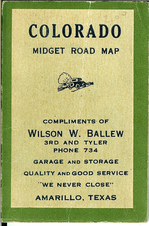
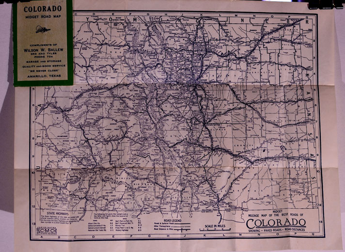
(Colorado
Midget Map) COLORADO
MIDGET ROAD MAP, 1926. Pocket
map in original printed green-bordered folder.
Compliments of Wilson W. Ballew, 3rd and Tyler, Garage
and Storage, Amarillo, Texas (Distributors of Reo, Hupmobile, General
Tires, Standard Batteries). Printed
on map: “Midget Mileage Map
of the Best Roads of Colorado, showing paved roads, road distances.”
Dimensions: 11-1/2 inches across by 9 inches in height.
Condition: near fine; folded. No
printer. Price:
$75.00
|
|
|
|