|
Site Map
Click on the
following web pages for more offerings:
HOME
About Us
Colorado
Artifactual
Albertype
Publications
Aspen,
Colorado
Business
Directories
Colorado
Colorado
Bottles, historical
Colorado
Business Directories
Colorado Maps
Colorado
Mining Stock Certificates
Colorado
Whiskey Jugs, historical
Cripple Creek,
Colorado
Cripple
Creek Mining Directories
Cripple
Creek mining stock certificates
Denver and
Rio Grande Railroad
Einstein,
Albert
Feynman,
Richard P.
Fitzgerald, F.
Scott
Gunnison
County, Colorado, including Crested Butte
Hecht, Ben
Hemingway,
Ernest
Hutchinson
Soda Bottles
Jackson,
William Henry
Leadville,
Colorado
Leadville
Directories
San Juan
Mountains, Colorado
Silverton
Railroad
|
|
Yes, we Accept:
PAYPAL,
Venmo & SQUARE |
We
are always interested in purchasing, whether you have a single item or an entire
collection for sale.
© 2024 Mt. Gothic Tomes
| |
|
|
|
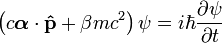
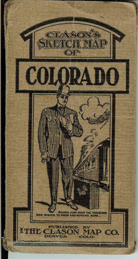
(Clason
Map Company) CLASON’S
SKETCH MAP OF COLORADO, pocket map published by The Clason Map
Company, Denver, Colorado, 1917. Original
illustrated light brown folding covers.
Folding map dimensions: 24-1/2 inches across by 18-1/2 inches in
height. Black, green and red
print. Index of towns and
cities with a population of 200 or more along right-hand margin.
Title of map: CLASON’S
GUIDE MAP OF COLORADO. Legend:
county seats; county lines; railroads; trunk line railroads; electric
railroads; national forest boundaries; national forest boundaries;
automobile roads; and main auto roads.
Spanish Trail, Santa Fe Trail, Midland Trail, Rainbow Route, Vernal
road, Greeley Road, Limon Road, Golden Belt Route and other trails and
roads identified. Significant
curatorial reinforcement on back of map hinges; otherwise, very good
condition.
PRICE:
$350.00
|
|
|
|
|
|
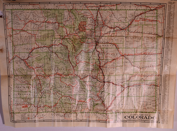
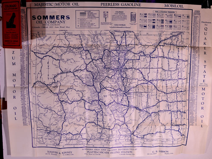
(Clason
Map Company) COLORADO
STATE AUTO ROAD MAP published by the Clason Map Company for the SOMMERS OIL COMPANY, 1925.
Pocket map. Original
illustrated orange folder. Index
of largest cities giving populations & key to map printed on left and
right sides of map. Map legend
of roads. Colorado state
highway signs. Trail &
highway markers. Dimensions:
27-1/2 inches across by 21 inches in height.
Blue print. Near fine
condition.
PRICE:
$250.00
|
|
|
|
|
|
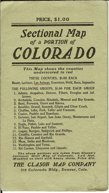
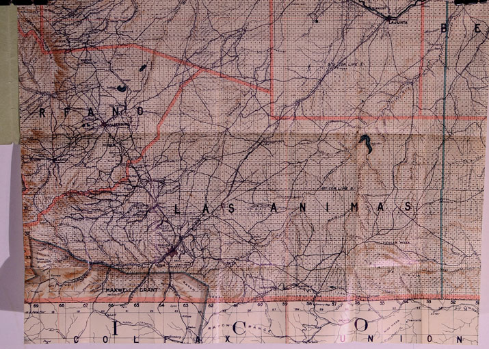
(Clason
Map Company) LAS
ANIMAS COUNTY: SECTIONAL MAP OF A PORTION OF COLORADO.
Circa 1905. Pocket map.
The Clason Map Company, 315 Colorado Building, Denver, Colorado.
This map shows the counties underscored in red: Las Animas.
Highly detailed map showing county lines; township lines; town,
cities, and railroad stations; rivers, creeks, lakes and other
topographical features. Agricultural
and livestock map. Printed in
tan, red, green, and black. Map
dimensions: 17-3/4 inches across by 14-1/4 inches in height.
Near fine condition.
PRICE:
$350.00
|
|
|
|
|
|
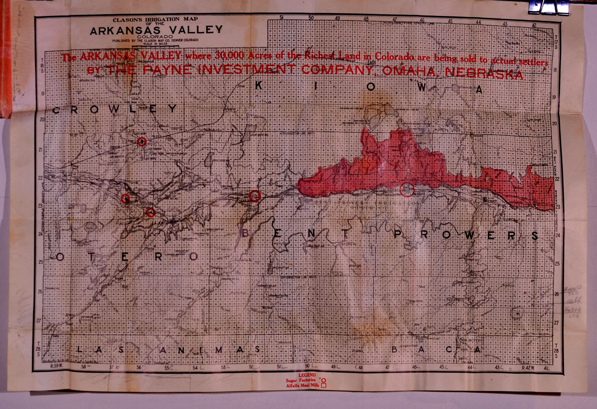
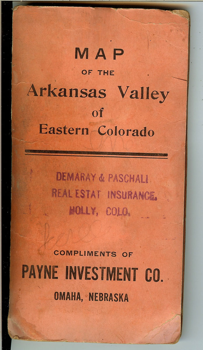
(Clason
Map Company) MAP
OF THE ARKANSAS VALLEY OF EASTERN COLORADO, published by the
Clason Map Company, Denver, Colorado, 1910.
Pocket map; blue print on orange stiff folding covers.
Showing Crowley, Kiowa, Bent, Prowers, and Otero counties, with the
northern portions of Las Animas and Baca counties.
“Compliments of Payne Investment Company, Omaha, Nebraska.
The Arkansas Valley where 30,000 acres of the richest land in
Colorado are being sold to actual settler by the Payne Investment Company,
Omaha, Nebraska.” Map shows
county lines, township lines, railroads and roads, topography, towns and
cities. Dimensions: 27-3/4
inches across by 19 inches in height.
Very good plus condition; some curatorial reinforcement on hinges.
Lenged: Sugar factories; Alfalfa Meal Mills.
Some pencil markings by previous owner.
PRICE:
$350.00
|
|
|
|
|
|
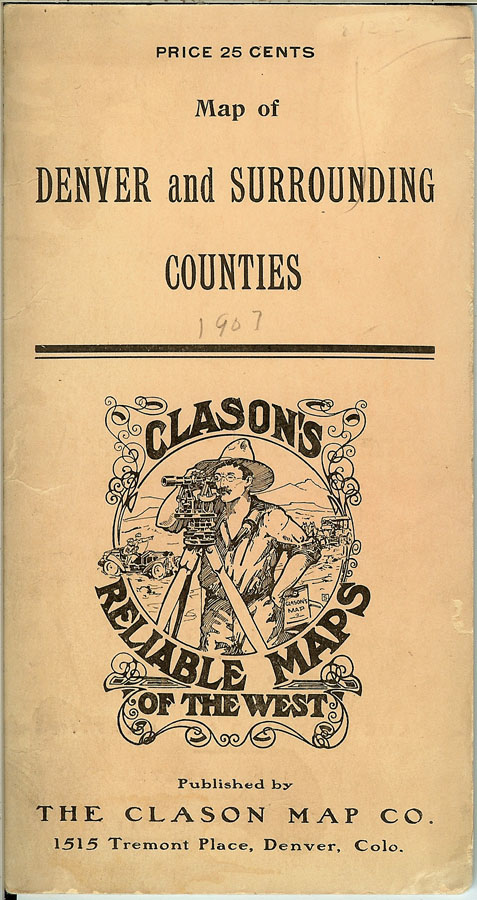
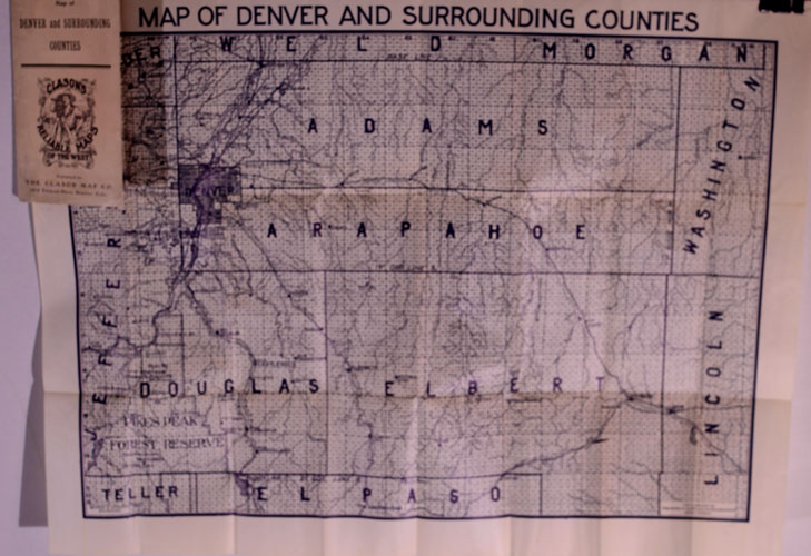
(Clason
Map Company) MAP
OF DENVER AND SURROUNDING COUNTIES, Colorado.
1907. Clason’s
Reliable Maps of the West, published by The Clason Map Co.,
1515 Tremont Place, Denver, Colorado, publishers of advertising and
reference maps. Pocket map in
original illustrated stiff pink folder.
Map dimensions: 21-1/2 inches across by 16-1/2 inches in height.
Counties shown: Adams, Arapahoe, Douglas, and Elbert, with parts of
Jefferson, Boulder, Weld, Morgan, Washington, Lincoln, Teller and El Pasoi.
Exhibits county lines, townships, towns and cities; Pikes Peak
Forest Reserve; railroads and roads. Black
print. Near fine condition
with some light curatorial reinforcement on back of hinges.
PRICE:
$350.00
|
|
|
|
|
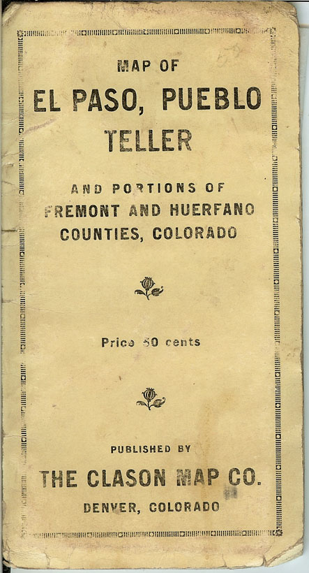
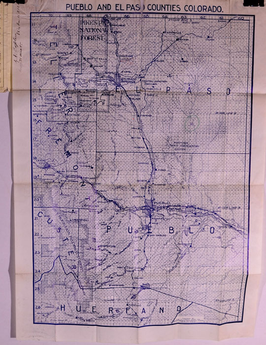
(Clason
Map Company) MAP
OF EL PASO, PUEBLO, TELLER and Portions of Fremont and Huerfano Counties,
Colorado. Pocket map
published by The Clason Map Company, Denver, Colorado, 1907.
Original printed cream-colored stiff folder.
Map title: PUEBLO AND EL PASO COUNTIES, COLORADO.
Map dimensions: 16 inches across by 22 inches in height.
Blue print. The Clason
Map Co. Advertising & Reference Maps, Denver, Colo.
County lines and townships. Towns
and cities. Railroads and
roads. Cities and towns
identified in the Cripple Creek Gold Mining District: Cripple Creek,
Victor, Goldfield, Gillett, Cameron, Independence, Elkton, Altman, and
Elkton. Wet Mountain National
Forest in Custer County, Colorado. Rivers,
streams and lakes. Some
curatorial mends on back of map, mostly along hinges.
Very good plus condition. SOLD |
|
|
|
|
|
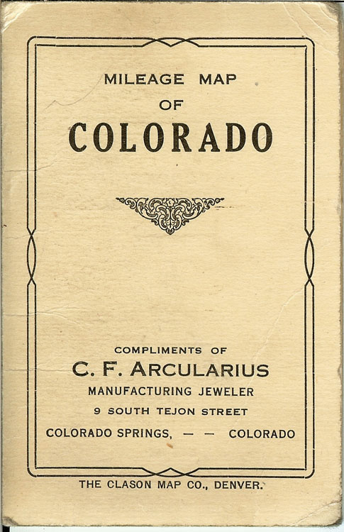
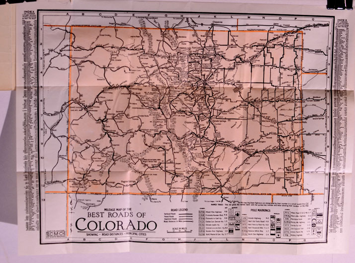
(Clason
Map Company) MILEAGE
MAP OF COLORADO. Mileage
Map of the Best Roads of Colorado, Showing Road Distances and Principal
Cities, ca. 1925. The Clason
Map Company, Denver, Colorado. Pocket
map in original printed cream-colored stiff folder.
“Compliments of C. F. Arcularius, Manufacturing Jeweler, ( South
Tejon Street, Colorado Springs, Colorado.
Index of Larger Citites Giving Populations & Key to Map.
Dimensions: 16 inches
across by 12-1/4 inches in height. Near
fine condition.
PRICE:
$200.00
|
|
|
|