|
Site Map
Click on the
following web pages for more offerings:
HOME
About Us
Colorado
Artifactual
Albertype
Publications
Aspen,
Colorado
Business
Directories
Colorado
Colorado
Bottles, historical
Colorado
Business Directories
Colorado Maps
Colorado
Mining Stock Certificates
Colorado
Whiskey Jugs, historical
Cripple Creek,
Colorado
Cripple
Creek Mining Directories
Cripple
Creek mining stock certificates
Denver and
Rio Grande Railroad
Einstein,
Albert
Feynman,
Richard P.
Fitzgerald, F.
Scott
Gunnison
County, Colorado, including Crested Butte
Hecht, Ben
Hemingway,
Ernest
Hutchinson
Soda Bottles
Jackson,
William Henry
Leadville,
Colorado
Leadville
Directories
San Juan
Mountains, Colorado
Silverton
Railroad
|
|
Yes, we Accept:
PAYPAL,
Venmo & SQUARE |
We
are always interested in purchasing, whether you have a single item or an entire
collection for sale.
© 2024 Mt. Gothic Tomes
| |
|
|
|
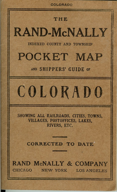
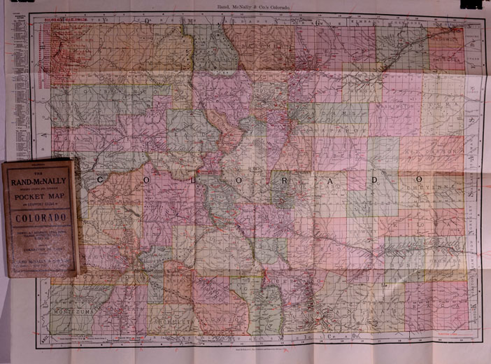
(Rand,
McNally & Co.’s) INDEXED
COUNTY AND TOWNSHIP POCKET MAP AND SHIPPERS’ GUIDE, COLORADO, 1911.
Rand, McNally & Co.: Chicago and New York, Map Publishers and
Engravers. Accompanied by a
New and Original Compilation and Ready Reference Index, Showing in Detail
the Entire Railroad System, The Express Company doing business over each
Road, and Accurately Locating all the Cities, Towns, Post Offices,
Railroad Stations, Villages, Counties, Island, Lakes, Rivers, etc.
The Special Features of this Pocket Map are: Locating the Branch or
Particular Division of Railroad upon which each Station is situated; the
nearest railroad point of all local places; designating money-order
post-offices; telegraph stations; and naming the express company doing
business at the points where the several companies have offices.
Population is given according to the 1900 Official Census.
62-page booklet/index. 5-color
detailed Colorado map. Dimensions:
27-1/2 inches across by 21 inches in height.
Near fine condition.
PRICE:
$450.00
|
|
|
|
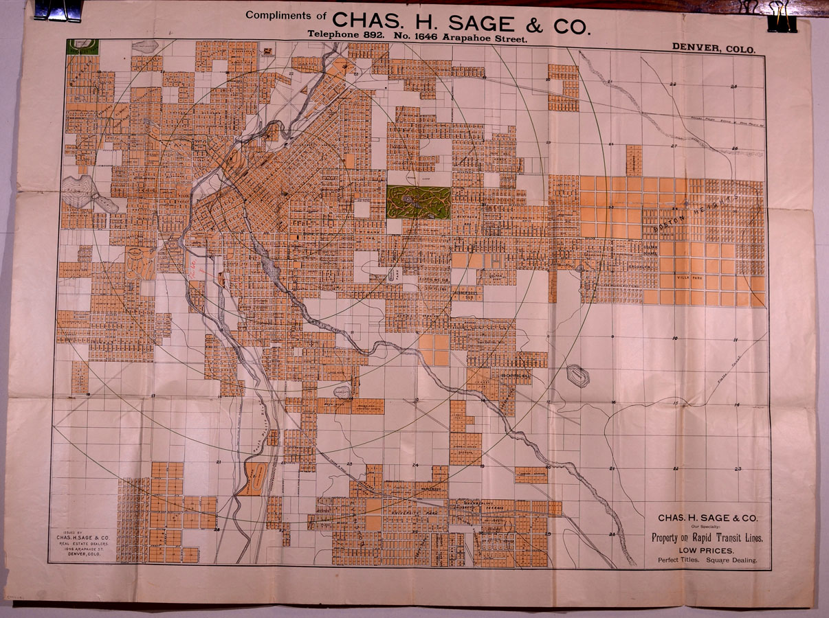
Denver
block, lot and plat map, circa 1887. Chas. H. Sage & Co. |
|
|
(Sage,
Charles H.) DENVER,
COLORADO ADDITIONS, LOT AND BLOCK MAP,
circa 1887. Chas.
H. Sage & Co., “Our Specialty: Property on Rapid Transit Lines.
Low Prices.
Perfect Titles.
Square dealing.”
Issued by Chas. H., Sage & Co., Real Estate Dealers, 1646
Arapahoe Street, Denver, Colo.
3-color map with the following dimensions: 33-1/4 inches across by
25 inches in height.
Shows Kansas Pacific Branch of the Union Pacific Railroad; Denver,
Texas & Gulf Railway; Denver, South Park & Pacific Railway; Denver
& Santa Fe Railway; Denver & Rio Grande Railway.
City Park in green.
Section and quarter-section lines.
Additions: Boston Heights; Villa Park; Evanston; Sheridan Heights;
Berkeley and Berkeley Park; Gladstone Heights; Irvington; Swansea, etc.
Since Fairmount Cemetery is not located on this map and was established in
1889-1890, we have dated this historical piece to be circa 1887.
Very good condition; some conservation on back of hinges.
SOLD
|
|
|
|
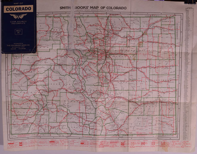
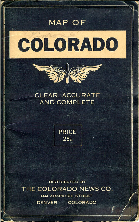
(Smith-Brooks
Printing Co.)
MAP OF COLORADO,
circa 1918. Pocket
map in original blue folder.
“Clear, Accurate and Complete.”
Distributed by The Colorado News Company, 1444 Arapahoe Street,
Denver, Colorado.
Map Title: SMITH-BROOKS MAP OF COLORADO.
Map dimensions:
21-1/2 inches across by 17-1/4 inches in height.
Red, green and black print.
Index of Colorado Towns and Cities along right-hand margin.
State and national highways identified in red: Albert Pike Highway;
Burlington Highway; Colorado to Gulf; Dallas-Canadian-Denver;
Denver-Joplin; Denver-Lincoln-Detroit; Golden Belt; Golden rod;
Kansas-Colorado Boulevard; Lincoln; National Old Trails road; National
Roosevelt-Midland Trail; Pike’s Peak to Ocean; Rainbow Route; Rocky
Mountain; Spanish Trail; Union Pacific; and, Victory.
Good plus condition: 3 inch strip of tape removed from near center
of map with some paper loss.
PRICE:
$200.00
|
|
|
|
|
|
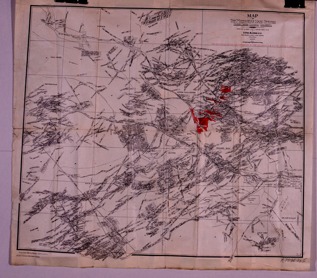
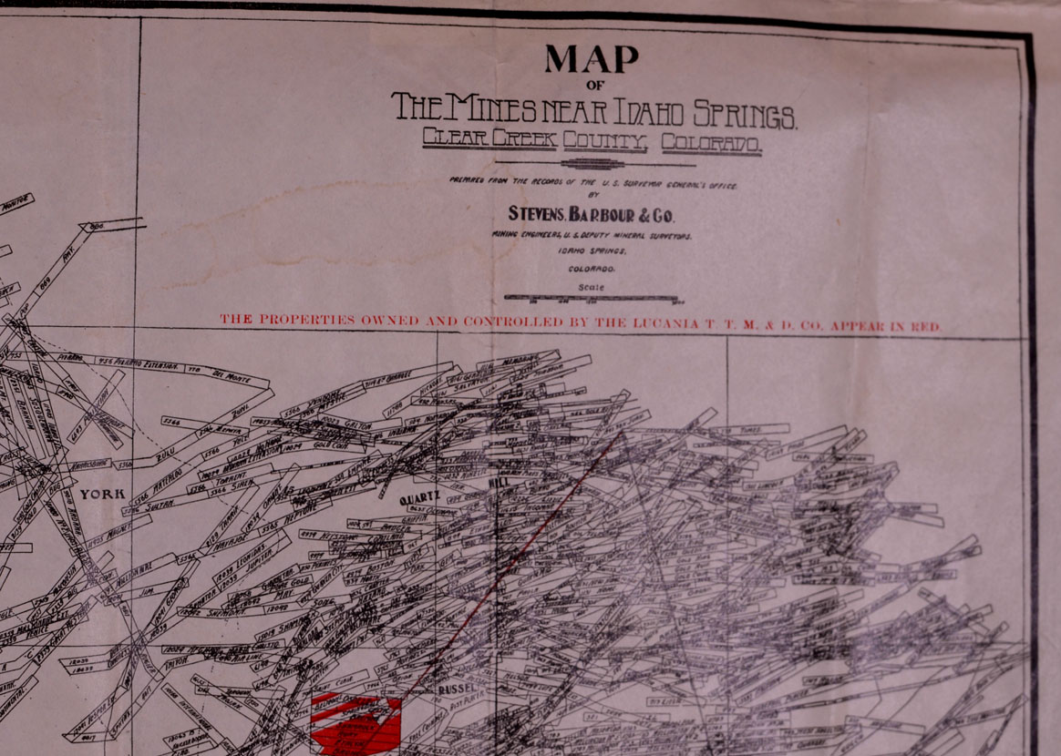
(Stevens,
Barbour & Co.)
MAP OF THE MINES NEAR
IDAHO SPRINGS, CLEAR CREEK COUNTY, COLORADO, 1902.
Prepared from the records of the U.S. Surveyor General’s Office
by Stevens, Barbour & Co., Mining Engineers, U.S. General Surveyors,
Idaho Springs, Colorado.
Dimensions: 18-3/4 inches across by 17 inches in height.
Printed by
the Idaho Springs Siftings Print, 1902.
Condition: very good; folded.
“The properties owned and controlled by the Lucania Tunnel,
Transportation Mining & Development Company appear in red.”
Mining claims identified; roads and railroads; townships; towns and
cities.
PRICE:
$475.00
|
|
|
|
|
|
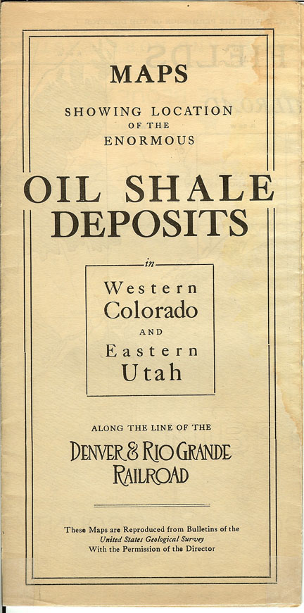
(Wadleigh,
Frank A. and Winchester, Dean E.)
MAPS SHOWING LOCATION OF
THE ENORMOUS OIL SHALE DEPOSITS in Western Colorado and Eastern Utah along
the Line of the Denver & Rio Grande Railroad.
Pocket map, circa 1920.
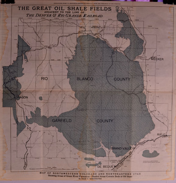
MAP OF NORTHWESTERN COLORADO AND NORTHEASTERN UTAH, Showing Areas
of Green River Formation – Shaded Areas Contain Beds of Oil Shale.
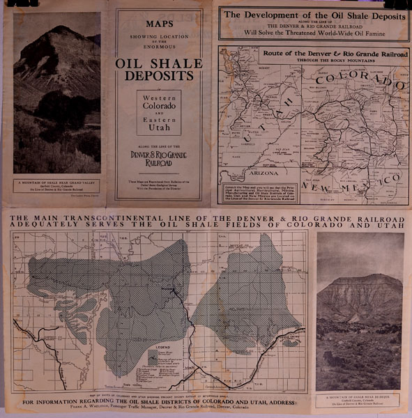
THE GREAT OIL SHALE FIELDS, Adjacent to the Line of The Denver
& Rio Grande Railroad.
“The Development of the Oil Shale Deposits Will Solve the
Threatened World-Wide Oil Famine.”
Map of the Main Transcontinental Line of the Denver & Rio
Grande Railroad adequately serves the Oil Shale Fields of Colorado and
Utah. Also,
Maps of Parts of Colorado and Utah showing present known extent of
Bituminous Shale.
Total of 3 maps on front and back of one she with dimensions of 17
inches across by 17-1/2 inches in height.
The Carson Press, Denver.
Two photographic illustrations.
Very good plus condition; several very light stains.
PRICE:
$350.00
|
|
|
|
|
|
|
|
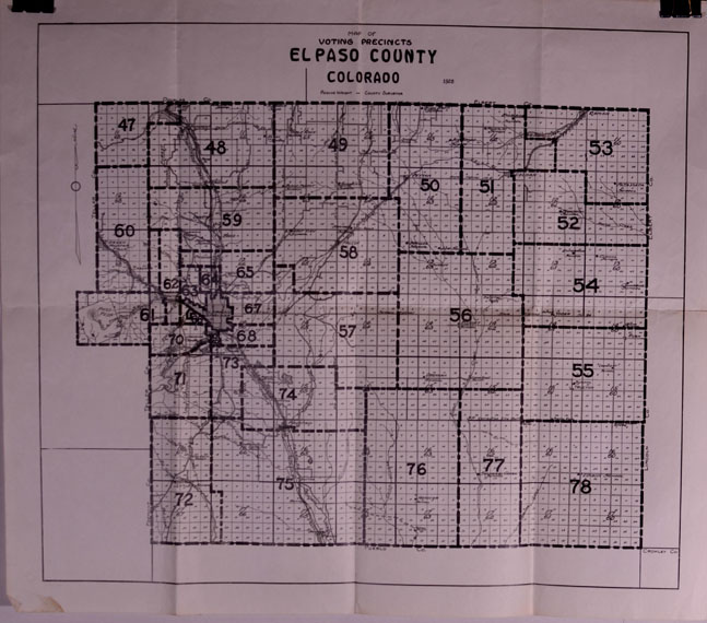
(Wright,
Roscoe, El Paso County, Colorado)
MAP OF VOTING PRECINCTS,
EL PASO COUNTY, COLORADO by Roscoe Wright, County Surveyor, 1928.
County lines; township lines; towns and cities.
Dimensions: 21-1/2 inches across by 19 inches in height.
Near fine condition; folded.
|
|
PRICE:
$175.00
|
|
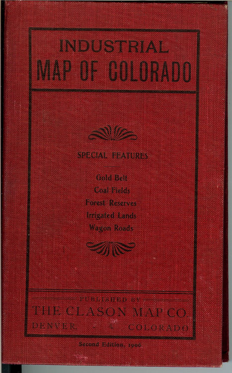
INDUSTRIAL
MAP OF COLORADO, Second Edition, 1906, published by The Clason Map
Company, Denver, Colorado. Pocket map. Original printed red
cloth. Special feature: Gold Belt; Coal Fields; Forest Reserves;
Irrigated Lands; Wagon Roads.
PRICE:
$2,500.00
|
|